News

UK Weather Forecast

UK Weather Forecast: What to Expect Over the Next Few Days Low pressure brings unsettled weather through much of the week and across the weekend. Heavy downpours initially from the south before a more conventional westerly flow returns. Wednesday: Rain and heavy downpours likely through the day!!! Rain and downpours from the word go on Wednesday with many locations experiencing them although parts of the E Midlands, East Anglia and the South East may see fewer to start with but you retain the cloud cover. These downpours or longer spells…

Read More

Extremely Dangerous Hurricane Milton Bears Down On Florida!!!

Hurricane Milton rapidly intensified into a Category 5 hurricane yesterday as it travels east through the Gulf of Mexico on its approach to Florida, with maximum sustained winds recorded at 180 mph. This marks Milton as one of the most powerful storms to threaten the Gulf Coast in recent memory. Its central pressure overnight has dropped to an extremely low 897 mb, which is indicative of a highly potent storm​. Milton’s development has been particularly alarming, transitioning from a tropical storm to a Category 5 hurricane in a very short…

Read More

September 2024: Wet For The South, Drier In The North.

Upside down weather is the only way to describe the pattern through September as the Atlantic jet stream remained generally south or across the south of the UK. This ensured unsettled weather remained across the south with pressure tending to be higher across the north and with it more in the way of settled weather. Rainfall will be the feature of note for September Rainfall but there was strong regional variation, with central and southern England seeing well above average values. Several counties including Bedfordshire, Gloucestershire and Oxfordshire provisionally recorded…

Read More

Will Hurricane Kirk affect the UK?

As Hurricane Kirk churns across the Atlantic, it is poised to transition into an extra-tropical storm, which could bring significant weather impacts to the UK. Currently located between the Cape Verde Islands and the Lesser Antilles, Kirk is forecast to strengthen mid-Atlantic before heading northward. By the time it reaches closer to the UK, it is expected to have lost its tropical characteristics but could still cause unsettled weather. How Ex-Hurricane Kirk Could Affect the UK According to the latest weather models, Kirk is likely to become a strong low-pressure…

Read More

UK Weekend Forecast

Headline: A weekend of two halves, drier on Saturday but further wet and windy weather due on Sunday. Saturday, September 28: For most Saturday will be a drier day overall with a good mixture of drier spells and variable clouds but be warned, it will be a cold start to the day and it won’t warm up significantly so expect a chilly day overall. There will unfortunately be some rain around, most notably across far N & NW Scotland and across the northern half of the UK there maybe the…

Read More

Hurricane Francine Set to Hit Southern U.S.

Later Today Hurricane Francine, a rapidly intensifying storm in the Gulf of Mexico, is projected to make landfall today along the Louisiana coast as a Category 2 hurricane, with sustained winds of around 100 mph. The storm, which has already prompted widespread evacuations and state emergency declarations, poses significant threats to parts of Texas, Louisiana, Mississippi, and Alabama​ Key Areas of Impact: Louisiana: The state is bracing for direct landfall, with hurricane warnings issued from Sabine Pass to Morgan City. Mandatory evacuations have been ordered in low-lying areas such as…

Read More

High Pressure For The Weekend But Thundery Downpours Flirt With The South!!!

As we head into the weekend, the UK’s weather will be largely dominated by a high-pressure system, bringing calm and settled conditions for most of the country. However, as the weekend draws to a close, the atmosphere may become more unstable, with the potential for thundery downpours late Sunday into Monday across southern parts of the UK. High pressure gradually settles across the UK through Friday and then drifts across to Scandinavia through the weekend. While this brings settled weather for most, a switch to easterly winds means some eastern…

Read More

Storm Lilian Set to Hit the UK this Friday Morning: What to Expect

The UK is bracing for impact as Storm Lilian, a powerful and rapidly developing weather system, is set to hit the country on Friday morning. There are warning of widespread disruption, with high winds, heavy rain, and coastal flooding expected across large parts of the UK. The Path of Storm Lilian Storm Lillian, still in development stage, will quickly gain strength as it moves eastward towards the British Isles. It is anticipated to make landfall early on Friday morning, primarily affecting western regions before sweeping across the rest of the…

Read More

Ex-Hurricane Ernesto Aims For The UK!!!

Hurricane Ernesto, a tropical storm that has gathered strength in the Atlantic, is expected to impact the UK in the coming days. While hurricanes rarely hit the UK with full force, remnants of these storms often bring unsettled weather conditions across the country. Here’s what to expect as Ernesto approaches our shores. 1. Transformation into a Post-Tropical Storm By the time Ernesto reaches the UK, it will have transitioned from a tropical hurricane into a post-tropical storm. This means that while it may no longer exhibit the tightly organised system…

Read More

Why Has the UK Summer Been So Bad This Year?

The UK has experienced a notably poor summer this year so far, characterised by unseasonably cool temperatures, persistent rainfall, and a lack of the usual sunny spells that many look forward to. Various factors have contributed to this disappointing weather, from atmospheric conditions to broader climatic trends. Let’s explore the primary reasons behind the UK’s dismal summer. 1. Impact of La Niña The global climate phenomenon known as La Niña can also influence UK weather. La Niña, characterised by cooler-than-average sea surface temperatures in the central and eastern Pacific Ocean,…

Read More

La Nina On The Way, Active Hurricane Season Expected!!!

La Niña, a climatic phenomenon characterised by cooler-than-average sea surface temperatures in the central and eastern Pacific Ocean, is set to make its presence felt once again. As meteorologists and climate scientists anticipate its return in 2024, there’s significant attention on how this pattern will influence the upcoming hurricane season. Historically, La Niña has been associated with changes in weather patterns globally, and its effects on the Atlantic hurricane season are particularly noteworthy. What is La Niña? La Niña is the cold phase of the El Niño-Southern Oscillation (ENSO) cycle,…

Read More

April 2024: A Bit Of Everything!!!

April in the United Kingdom is often characterised by its capricious nature, and this year was no exception. Across the country, residents experienced a diverse mix of weather conditions, showcasing the unpredictable temperament of spring. Temperature Variability April 2024 saw significant temperature fluctuations. The month started on a relatively mild note, with temperatures hovering around average for early spring. Southern England enjoyed several days of warmth, with temperatures reaching the high teens (Celsius). London and surrounding areas basked in these pleasant conditions, prompting many to flock to parks and outdoor…

Read More

UK Thunderstorm Forecast

Thunderstorm Watch 12th May 2024: Instability will build today ahead of a trough feature that is currently situated to the south-west and across France. CAPE (measure of instability) values in excess of 1200 J/kg are expected this afternoon and is more than enough to support and maintain thunderstorm activity. As the trough shift north eroding the stable layer, thunderstorms will break out across parts of Wales and the W Midlands before developing further north into NW England. Heavy and torrential rainfall, hail, strong convective wind gusts and some hail will…

Read More

Thundery Downpours Likely Later On Wednesday Into Thursday!!!

Tomorrow evening promises an electrifying show across central and northern/north-eastern France, along with a potential sprinkle of excitement in western Belgium. It’s all thanks to a warm air mass mingling with a hint of instability, brewing the perfect recipe for heavy, thunderous downpours. Our trusty thunderstorm risk data paints a vivid picture: red hues signal a high chance of thunderstorms bursting forth. But even as night falls, the risk remains palpable across the southern reaches of the UK, albeit with a slightly toned-down intensity. These thundery downpours will develop in…

Read More

Large Devastation After Weekend Tornado Outbreak!!!

Over the course of the weekend, a series of devastating tornadoes tore through the heartland of America, leaving a trail of destruction and claiming the lives of at least five individuals. From the plains of Texas to the farmlands of Iowa, communities were left reeling in the wake of the powerful storms. The National Weather Service recorded an astonishing tally of nearly 130 tornado reports since Friday, underscoring the magnitude of the weather event. Towns such as Minden in Iowa, Elkhorn in Nebraska, and Sulphur and Holdenville in Oklahoma bore…

Read More

Stratovolcano Mount Ruang Erupts: Implications for Global Weather Patterns

Indonesia, known for its stunning landscapes and vibrant culture, portrayed a very different canvas as Ruang, one of its most active volcanoes, erupted violently recently. The eruption sent a massive plume of ash and volcanic gases soaring into the atmosphere, some 50,000 feet up. While the immediate impact is felt locally, the repercussions of such volcanic activity could extend far beyond the borders of Indonesia, potentially influencing weather patterns on a global scale in the coming months and years. Ruang’s eruption is not an isolated event but rather part of…

Read More

Dubai Underwater: Unravelling the Recent Floods and the Role of Cloud Seeding

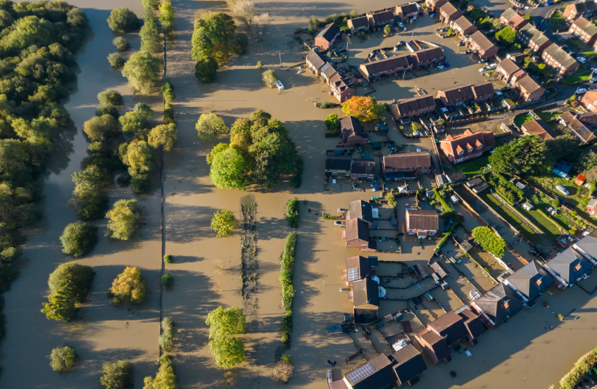
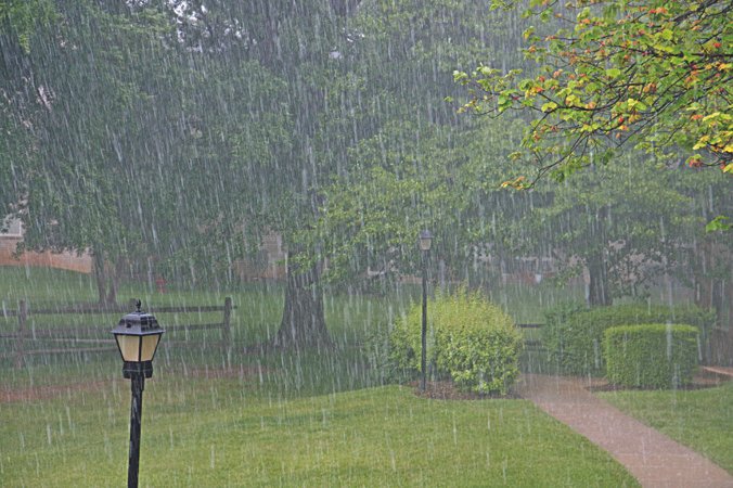
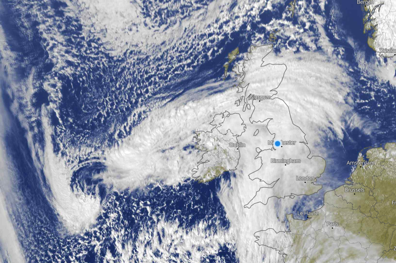
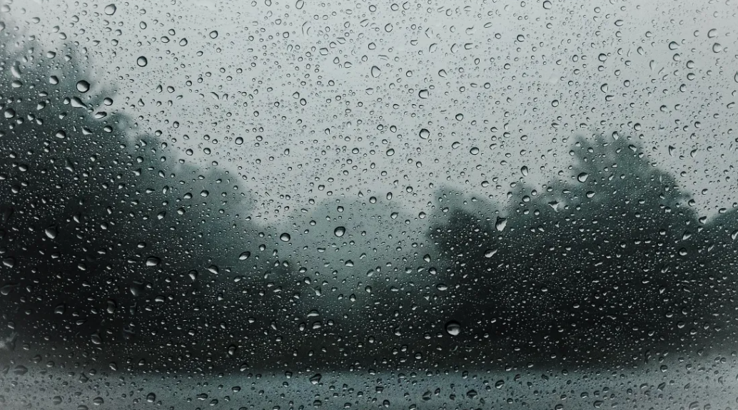
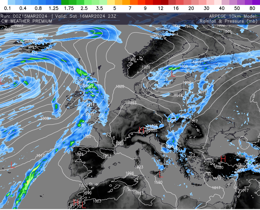
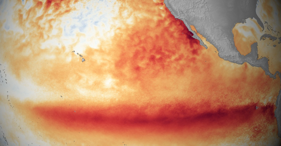
In a city known for its towering skyscrapers, opulent lifestyle, and arid climate, Dubai experienced an unexpected turn of events recently as torrential rains inundated the streets, causing widespread flooding. The deluge caught residents and authorities off guard, highlighting the vulnerability of even the most meticulously planned urban landscapes to the whims of nature. The Deluge Unfolds Dubai, nestled along the Persian Gulf coast, typically experiences a desert climate characterised by scorching temperatures and minimal rainfall. However, in recent years, irregular weather patterns attributed to climate change have disrupted this…

Read More

High Pressure Knocking On the Door!!!!

As the UK braces for the arrival of an impending high-pressure system later this week, meteorological projections unveil a nuanced forecast, highlighting not only the system’s influence but also the intricacies of weather dynamics in the region. Let’s delve deeper into the anticipated atmospheric conditions and their implications across the country. The High-Pressure System: Expected to settle over the UK in the coming days, the high-pressure system brings with it a gamut of weather phenomena. Initially, as the system establishes itself, a noticeable chill in the air is anticipated due…

Read More

March 2024: A Dull, Wet & Mild Month Overall But With One Or Two Surprises!!!

As March bid farewell to the winter chill, it brought with it a mixed bag of weather across the UK, painting a picture of unsettled skies and damp landscapes. The month kicked off with a shiver as temperatures plunged below the seasonal norm, sending a cold snap sweeping across the country. Southern regions, in particular, felt the bite of winter’s lingering grasp. Even as the nation thawed, snowflakes danced their way through parts of southwest England in early March, casting a frosty veil over the countryside and causing a ripple…

Read More

Stormy Weather Forecasted to Sweep Across the Midwest USA

Residents of the Midwest USA are bracing themselves for an onslaught of stormy weather expected to sweep through the region this week. Meteorologists are issuing warnings of severe thunderstorms, heavy rainfall, and potential flash flooding across several states, prompting communities to take precautionary measures to ensure their safety. According to the National Weather Service (NWS), a potent weather system is poised to bring a series of powerful storms to the Midwest starting from Monday 9th April. The system is forecasted to originate from the west, gaining strength as it progresses…

Read More

Low Pressure This Week, Is Winter Preparing To Make A Comeback?

One of the enduring characteristics of British weather is its variability and unpredictability. It’s not uncommon to experience a mix of sunshine, rain, showers, and even the occasional burst of wintry weather, all within the span of a single week. This week is likely to be no exception, with a blend of different weather patterns expected across the country. Showers and Sunshine: Throughout the week, we can expect a mixture of sunshine and showers to prevail. While some regions may enjoy some spells of sunshine, others may contend with passing…

Read More

UK Winter 23/24 Review: A Dull Tapestry Of Weather!!!

As the winter of 2023/24 unfolded across the United Kingdom, it brought with it a blend of familiar patterns and surprising deviations from the norm. Drawing upon the climatological averages from 1991 to 2020, this season’s weather exhibited noticeable shifts in temperature, rainfall, and sunshine hours or lack off. Temperatures: Despite many initial forecasts and mid term models hinting at a colder-than-average winter, much of the UK experienced milder temperatures throughout the season. While some regions encountered sporadic cold snaps and frosty mornings, overall, temperatures remained above the long-term average.…

Read More

A Mixed Bag Of Weather This Week!!!

As we step into the week ahead, the weather in the United Kingdom promises a diverse array of conditions, keeping us on our toes. From chilly showers to fleeting spells of sunshine, here’s a summary of what to expect over the several days. The upcoming week in the UK is characterized by a mix of weather patterns, making it a true testament to the country’s notorious variability. Expect fluctuations in temperatures, precipitation, and even the occasional appearance of sunshine, something we didn’t see a great deal of through winter as…

Read More

Weekend Quick Cast

Overview: Broadly unsettled overall as low pressure continues to dominate the weather. Further rain and showers will be possible with the winds blustery at times. Saturday: Cold but dry start for many with plenty of sunny spells possible, some frost and fog possible locally here and there. Cloud will increase from the west into the afternoon and rain will push in to western parts, spreading across the country by late evening/night. Turning windy in the west too. Sunday: Rain in the south and east will slowly clear away. Showers will…

Read More

El Nino Set To Flip To La Nina!!!

Weather patterns have always fascinated humanity, from the ancient civilizations to modern meteorologists. Among the most intriguing phenomena is the El Niño Southern Oscillation (ENSO), a climatic cycle that influences weather patterns worldwide. As we transition from El Niño to La Niña this year, understanding these shifts becomes crucial for communities, economies, and ecosystems globally. El Niño, characterised by warmer-than-average sea surface temperatures in the central and eastern Pacific Ocean, has been making its presence felt in recent times. This phase often brings about disruptions in weather patterns, such as…

Read More

Stratospheric Wind Reversal, What Next?

In a mesmerising display of atmospheric dynamics, Earth’s stratosphere has recently orchestrated a rare performance, captivating scientists and weather enthusiasts alike. The spotlight falls on the unexpected reversal of winds in the stratosphere, a phenomenon that offers a fascinating glimpse into the intricate dance of our planet’s atmospheric layers. The stratosphere, the second major layer of Earth’s atmosphere extending from about 10 to 50 kilometres above the surface, is known for its relatively stable and stratified nature. However, the typically westward-blowing winds in the stratosphere encountered an abrupt change of…

Read More

Convective System Spawns Likely Tornado In Greater Manchester!!!

Firstly apologies for the lack of updates yesterday, I was struck down with the old covid virus. Not pleasant at all and still not 100% but the weather waits for nobody. With true irony trust the weather to be so active as well. A line segment built in the Irish sea close to NW Wales in line with an upper trough but this started to show a bowing feature, which means very strong winds developing within the system and quickly became a small scale mesoscale convective system. The lightning data…

Read More

Cold Weather Latest

Cold air from the north-east has spread across the country over the past couple of days and is or will bring snow to some parts of the UK across the next several days, along with widespread frosts and ice also bringing hazards. Cold air has been building across Scandinavia for some time now and thanks to an easterly flow we are now tapping into this cold air. Snow showers are already affecting eastern parts of the UK and these will only continue for the next few days, some accumulations will…

Read More

Cold Waft On The Way But No Snomageddon!!

The tabloids dont miss a trick these days, searching through weather charts they dont understand for the slightest excuse to post outrageous articles. This week has been no different as the models continue to show a cold waft dropping south across the UK later this week. Cue the “Epic snow to fall across the UK, here are the exact dates” stories. In essence they just look at weather charts beyond the scope for reasonable outcomes and are simply wish casting. The cold air due later this week is simply nothing…

Read More

Storm Ciaran Latest

Storm Ciaran will bring strong winds and heavy to parts of France and southern England late on Wednesday and through much of Thursday. The exact track it still hard to pin as yet but growing confidence is that the worst winds winds will come through the English Channel and northern France. Grab all the latest here. Update: 01/11/23 (9.30) Find the latest update below. Storm Ciaran is now under going rapid cyclogeneses and will most likely produce a sting jet later today. This bring the risk of 100 mph winds,…

Read More

Stormy Week Ahead!!!

It’s autumn and that usually heralds active weather across the UK, especially late in autumn but next week we really ramp the weather up. The jet stream is really going to fire up through the week, bringing deep lows across the UK. One very notable storm will arrive late Wednesday into Thursday. Current model guidance has this low tracking across southern parts of the UK and northern France with the worst winds likely through the English Channel are. This storm has the hallmarks of being quite nasty with rapid cyclogenesis…

Read More