Friday 26 June 2026 will undoubtedly be remembered as one of the most impressive convective days of the year across North West England.
Following another exceptionally hot and humid day, the atmosphere was primed for thunderstorm development. While many areas remained dry for much of the afternoon, one particular boundary proved to be the catalyst for a rapidly intensifying storm that evolved into what appeared to be a supercell or supercell-like thunderstorm building across Merseyside and affecting parts of Lancashire and Greater Manchester.
The Set-Up
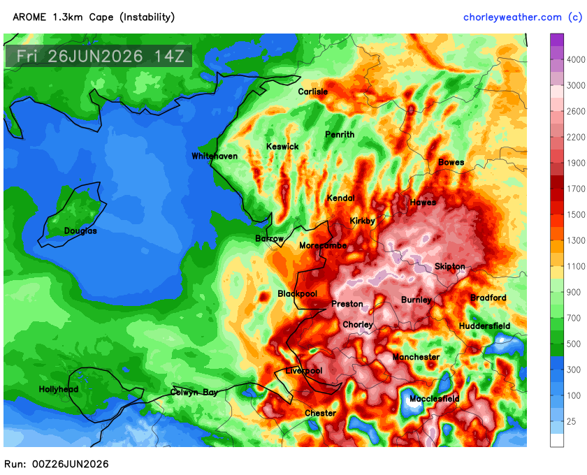
Temperatures had climbed well into the 20s or early 30’s, with abundant low-level moisture creating an increasingly unstable atmosphere. Despite this, much of the region remained capped through the early afternoon, preventing widespread convection from developing. The game changer was the arrival of the Irish Sea sea breeze.
As sea breezes started to ramp up, it collided with the much hotter inland air mass across parts of Merseyside, West Lancashire and Cheshire. The more westerly sea breeze pushed inland and met the warmer SE’ly flow, this created a narrow but intense zone of low-level convergence, forcing warm, humid air rapidly upwards. CAPE (Convective Available Potential Energy) values in excess of 2500 J/kg, locally in excess of 3000 Jkg showed once that this boundary finally broke the cap, explosive thunderstorm development was increasing likely and subsequently followed.
Rapid Intensification
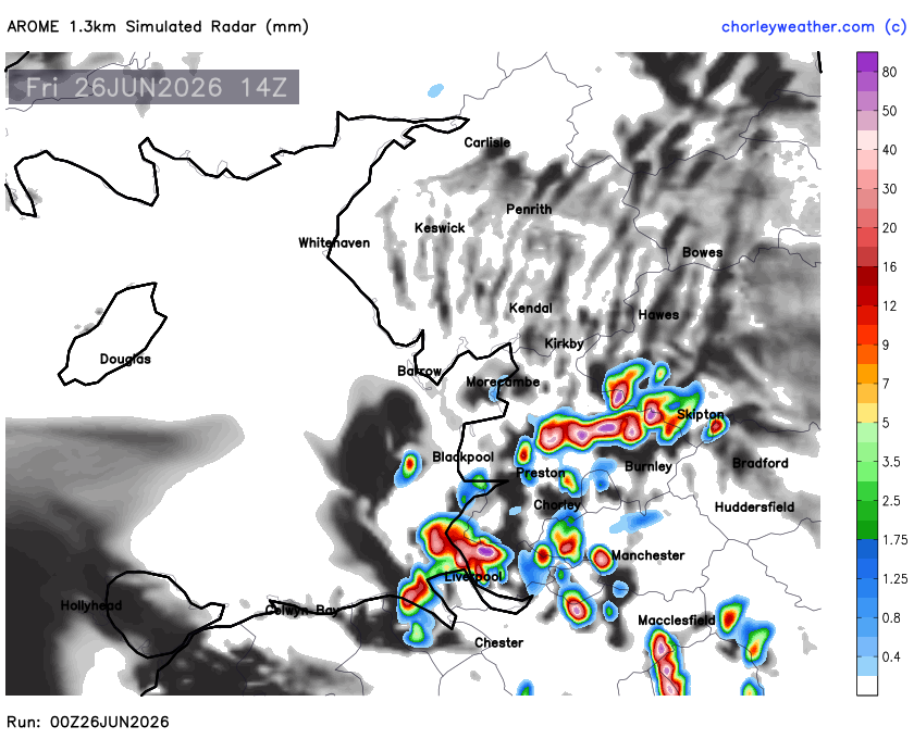
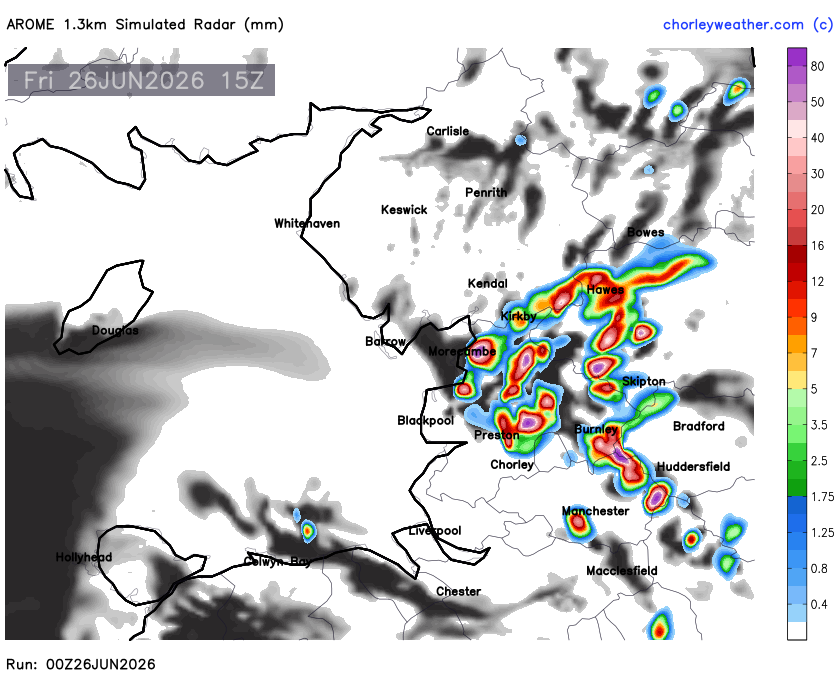
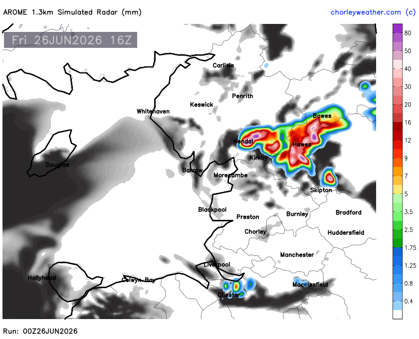
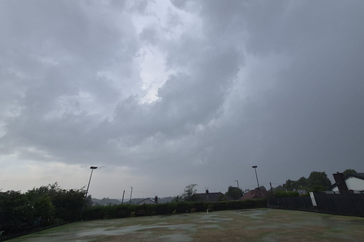
What initially appeared to be an ordinary shower quickly transformed into one of the strongest thunderstorms of the day. Radar imagery showed the storm growing rapidly into a dominant cell as it tracked across the Liverpool–Warrington corridor before moving eastwards/northeastwards.
Lightning activity increased dramatically in only a matter of minutes. Live detection networks recorded over 5,700 lightning strikes, with strike rates exceeding 1,000 strikes per hour at the storm’s peak. The continuous lightning and persistent electrical activity suggested an exceptionally powerful updraught within the storm.
Large Hail Falls
One of the clearest signs that this was no ordinary thunderstorm came from reports of large hail. Images supplied to CW Weather showed large hailstones capable of causing damage to vehicles and vegetation. Hail of this size requires extremely strong upward motion within the storm, allowing hailstones to remain suspended inside the cloud while repeatedly collecting layers of ice before finally falling to the ground. Large hail combined with intense rainfall and frequent lightning, confirmed the storm had reached severe levels.
Was it a Supercell?
Without access to full Doppler velocity radar data, it isn’t possible to confirm a supercell with complete certainty.
However, several characteristics strongly suggest the storm displayed supercellular behaviour:
- Rapid explosive development.
- Persistent rotating-looking radar structure.
- Extremely frequent lightning.
- Large hail core.
- Strong convective winds/downbusrts
- A long-lived dominant storm rather than a short-lived pulse thunderstorm.
Whether officially classified as a supercell or not, it behaved much more like an organised severe thunderstorm than the typical summer shower often experienced across the North West.
Flooding
Despite the intensity of the rainfall, there were no widespread reports of significant flash flooding across Merseyside, Lancashire or Cheshire at the time of writing. Some roads were briefly affected by surface water beneath the heaviest downpours, but no major flooding incidents or emergency responses appear to have been reported in relation to this particular storm. That being said I saw the intense rainfall for myself and ts almost certain some temporary flooding occurred, especially in prone locations.
Why This Storm Was So Impressive
North West England is no stranger to summer thunderstorms, but storms of this intensity remain relatively uncommon. This event perfectly demonstrated how a seemingly small feature such as a sea-breeze boundary can completely transform the atmosphere. Once the cap was breached, the environment was capable of supporting an exceptionally vigorous thunderstorm that rapidly became electrically active and severe.
Events like this are notoriously difficult for weather models to pinpoint exactly, with the precise location of convergence often making the difference between a dry afternoon and one producing large hail, torrential rain and thousands of lightning strikes. Again though our in house model using AROME data did indeed foresee the convergence zone set up and the resulting explosive development. The simulated radar data below while not absolutely perfect with the output, wasn’t far off at all and continues to be one of the better models in such set ups.