As forecasters, it’s always important to conduct seasonal reanalysis — not just to see what happened, but to understand why it happened and where expectations aligned or diverged from reality.
Heading into winter 2025–26, there were strong signals for a blocked pattern across the Northern Hemisphere. In many respects, that signal verified. However, while the season came close to delivering a classic UK winter, it ultimately fell just short of being remembered as one.
So what went right — and what didn’t?
A Strongly Blocked Hemisphere
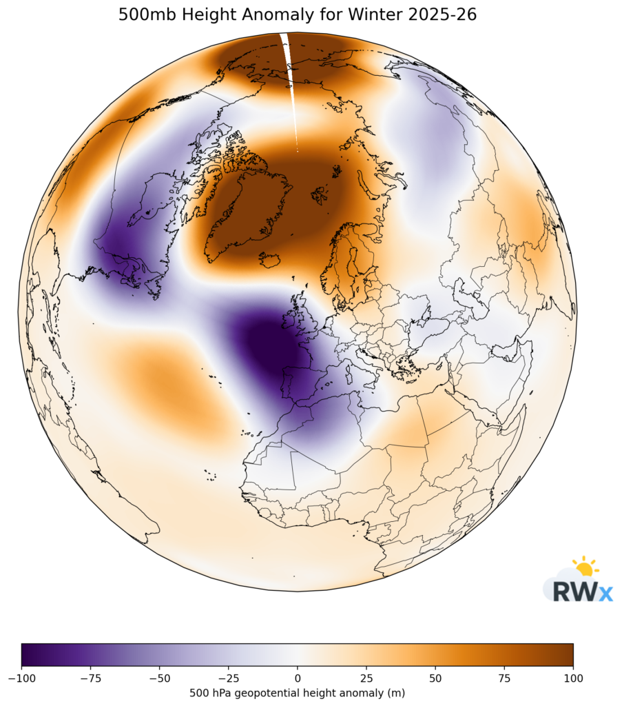
The 500 hPa height anomaly chart for winter shows clear and persistent blocking:
- Strong positive height anomalies across Greenland and the Arctic
- Additional ridging extending toward Scandinavia
- Lower heights positioned to the southwest of the UK
This is a classic blocked hemispheric configuration. When we see this setup, especially with northern blocking in place, expectations naturally rise for colder conditions in the UK.
And at times, the ingredients were close.
However, as always in UK winter forecasting, positioning and flow angle are everything.
The Importance of Flow Angle
While blocking was present to our north, the UK frequently sat between that northern high latitude block and low pressure systems tracking to the southwest.
Instead of a sustained, clean easterly flow, the UK more often experienced a south-easterly trajectory.
That distinction is crucial.
A classic “Beast from the East” setup typically requires:
- A firm high over Scandinavia
- Low pressure to the south or southwest
- A sustained easterly or east-northeasterly flow sourcing deeply cold continental air
This winter, the angle of attack simply wasn’t quite right. The airflow was often modified before reaching the UK.
Small directional differences can have major consequences in winter setups.
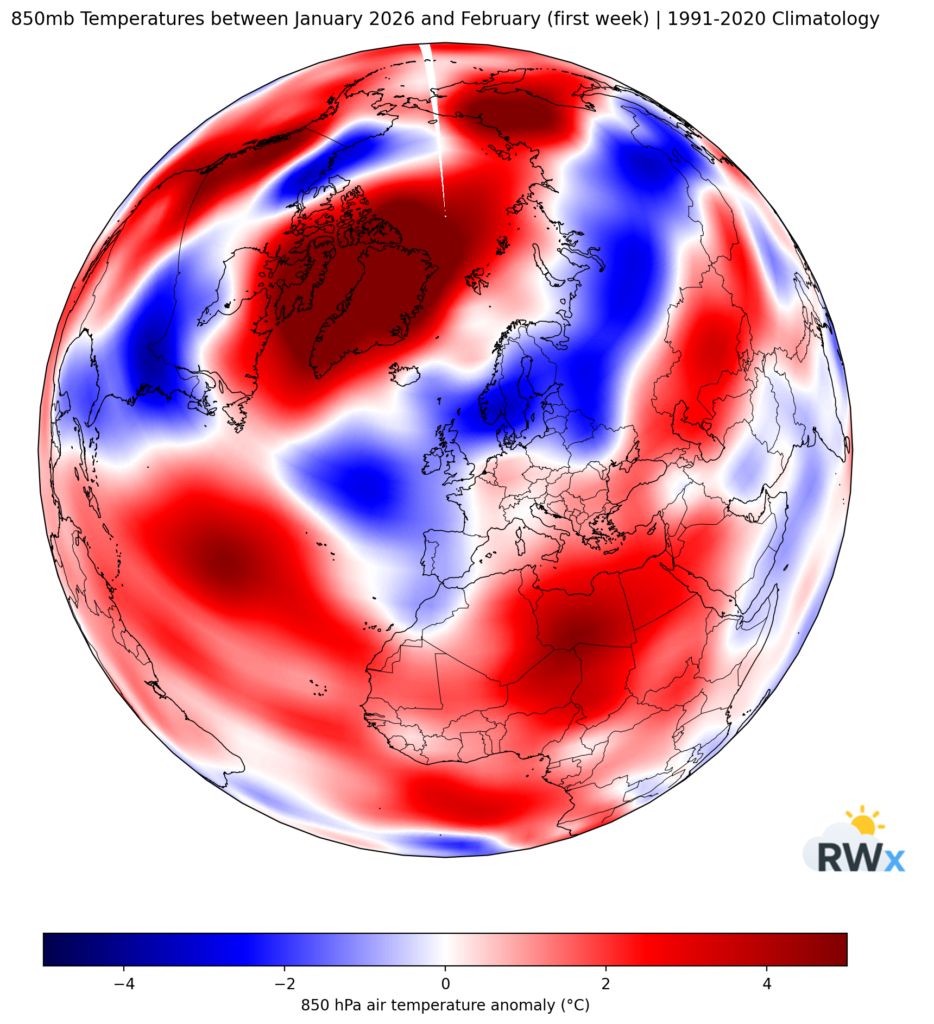
What the 850 hPa Temperatures Tell Us
To assess the true character of the air mass, we look at 850 hPa temperatures (around 1,500 metres above sea level). This level removes many surface influences and provides a clearer picture of air mass origins.
The anomaly chart for January through early February shows:
- Colder-than-average air locked into parts of Scandinavia
- More mixed or near-average anomalies across western and central Europe
- Only intermittent colder incursions reaching the UK
In other words, while there was a cold reservoir available over northeastern Europe and toward Siberia, the UK was not consistently tapping into the deepest part of that cold pool.
At times the flow nudged more easterly and colder air did reach the country — particularly across Scotland — but these periods were not sustained.
The Role of Low Pressure
Another key factor was the frequent presence of low pressure systems to the southwest of the UK. These systems:
- Disrupted the clean easterly feed
- Modified the incoming air mass
- Deflected some of the colder continental air away from southern areas
As a result, Scotland more frequently accessed colder air, while southern parts of the UK often remained on the marginal side of events.
The setup was close — but just not perfectly aligned.
Why Blocking Doesn’t Always Guarantee Severe Cold
This winter is a good example of an important forecasting lesson:
Blocking alone does not guarantee a classic cold winter.
For the UK to experience a truly severe easterly pattern, three things must align:
- Strong northern or Scandinavian blocking
- Correct positioning of downstream lows
- A sufficiently cold continental source region
If any one of these elements is slightly misplaced, the outcome changes significantly.
Even in winters featuring sudden stratospheric warmings or high-latitude blocking, the final surface impact depends heavily on flow trajectory and upstream thermals.
A Look Across the Atlantic
Interestingly, the same hemispheric pattern proved more favourable for parts of North America. Downstream troughing over the eastern United States allowed a more direct northerly flow into the Midwest and eastern states.
In that case, the flow angle aligned more cleanly with the available cold reservoir, resulting in widespread snow and significant winter weather across those regions.
It highlights once again how small positional differences in large-scale patterns can produce very different regional outcomes.
Final Thoughts
Winter 2025–26 will be remembered as a blocked winter that came close to delivering something more notable for the UK.
The ingredients were there:
- Strong high-latitude blocking
- Periodic cold intrusions
- A supportive hemispheric setup
But the flow angle and positioning of low pressure systems prevented a sustained, classic easterly outbreak.
As ever in UK winter forecasting, it’s often not about whether the block exists — it’s about exactly where everything sits.
And this winter was a reminder of just how fine those margins can be.